In commemoration of World Biodiversity Day 2024, this article was written on behalf of the Institute of Marine Affairs (IMA) by Hannah Lochan.
Did you know that the Convention on International Trade in Endangered Species of Wild Fauna and Flora (CITES) is currently protecting over 40,000 species of flora and fauna from over-exploitation?
As efforts to rehabilitate, conserve and preserve wildlife, and their habitats, become increasingly vital, digital technologies are constantly emerging and evolving to aid in these efforts.
Countries are adopting practices like using drones to plant trees, anti-poaching transmitters and artificial intelligence to track wildfires.

Trinidad and Tobago Cetacean Sighting Network (TTCSN)
The TTCSN uses a variety of bioacoustics and visual observations to monitor cetaceans (whales, dolphins and porpoises) around the country.
Using a hydrophone to capture data in the marine environment, bioacoustics is the study of animal sounds in nature to understand species population and occurrence, animal communication and the impacts of humans on species.
Visual studies incorporate the use of photography and videography to identify species and individuals.
Combined, these tools allow key characteristic features to be recorded and compared as well as provide insight into cetacean migration patterns and survival.

Apart from the critical research, the TTCSN also hopes to sensitise the public about the importance of cetaceans as part of a campaign to call for their conservation and protection.
The International Union for Conservation of Nature – SSC Cetacean Specialist Group – has noted that there are five cetacean species and 19 subspecies which are critically endangered while 12 species are endangered.

The Maritime Ocean Collection (MOC)
When it comes to the use of technology for conservation efforts, the MOC can be used as another example as the project uses digital technology to highlight the coral reefs of Tobago.
Coral reefs host almost 25 per cent of marine life and provide a variety of ecosystem services ranging from sources of food to shoreline protection.
Aiming to connect people and coral reefs, the MOC utilised state of the art 360° imagery of Tobago’s coral reefs, Google Street View, smartphone technology and videography to create a catalogue of 360° photographs.

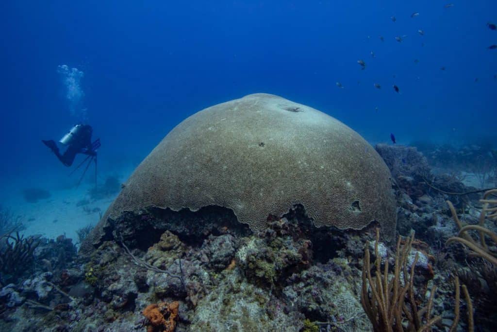
During a series of community outreach events, people were invited to use Virtual Reality (VR) goggles which allowed them to view the collection of photographs and feel as if they were swimming among the wrasses (a species of fish) in Culloden Bay or hovering above one of the world’s largest brain corals in Speyside.
Without requiring people to venture into the seas, the project has increased accessibility to Tobago’s reefs as many Trinbagonians may not have visited these sites before.
The collection of remarkable images is the first online coral reef collection and serves as a baseline for scientific comparison in years to come.

The Institute of Marine Affairs (IMA)
The IMA uses innovative technology in different ways to help monitor and protect the environment and local wildlife.
In 2016, the Turtle Village Trust of Trinidad and Tobago received funding for the National Sea Turtle Tagging and Monitoring Programme to track sea turtles using satellite trackers.
IMA assisted in processing the tracking information.
Between 2016 to 2022, 18 turtles were successfully tagged including green and hawksbill turtle species.

The tracking devices were attached to the turtles’ carapace (top shell) and every time they surface for air, the tags will transmit a signal to a satellite allowing data like their location to be recorded.
The movement of these turtles were tracked with many heading up the Caribbean archipelago with one reaching Haiti and another venturing as far as Central America.
This information is critical as it allows for the monitoring of migration patterns, populations, and habitat use, all of which are vital in conservation management of these endangered species.

The IMA also uses satellite imagery (images taken from space) to periodically map critical habitats, mangroves, and seagrasses, which are home to diverse species inclusive of vulnerable and endangered species.
In doing this, patterns of habitat fragmentation or even habitat expansion could be assessed giving insight into potential impacts on species.
Using this technology, and supported by ground truthing, the IMA was able to document the expansion of seagrass beds in Bon Accord Lagoon, Tobago.
These Thalassia testudinum (turtlegrass) beds provide habitat and feeding grounds to an array of marine species including conch, lobster, juvenile fish and sea turtles.

In other cases, the IMA has used a combination of aerial photography, LiDAR survey, and laser scanning of mangrove trees to map the extent of mangrove forest as well as determine the aboveground carbon in these forests.
A terrestrial laser scanner was used to recreate the woody parts of the mangrove trees in three-dimensions to get a more accurate biomass measurement.
Mangrove forests store as much as four times more carbon than terrestrial forests therefore helping with climate change mitigation.
These ecosystems also provide habitat and food for a variety of animals including birds, fish, crustacean (crabs), reptiles (caiman and snakes) and mammals.

On February 23, 2024, the IMA received an advanced drone and observed its inaugural flight.
This drone has many features which makes it exceptionally useful in supporting IMA’s research.
Boasting laser scanning tools and a LiDAR sensor, it has capabilities of taking high quality, detailed aerial images for mapping purposes.
This drone will be utilised to facilitate habitat mapping and wildlife monitoring.
How can individuals help contribute to wildlife protection in this digitally driven world?With most people always having a smartphone within arm’s reach, you can:
- Partake in citizen science initiatives such SpeSeas’ Turtle Spotter Programme, or iNaturalist by submitting photos of wildlife observed. Here you can contribute your data to scientists trying to study these species, or even get assistance from experts in identifying the animal you photograph.
- Report whale or dolphin activity to info@ttcsn.org or @ttcsn_org.
- Report mammal and turtle strandings, fish kills, coral bleaching, lionfish sightings and other environmental incidences on IMA SeaiTT App and assist with monitoring the environment.
- Share information on social media about wildlife protection and encourage others to do their part.


